
Ralphs
Discount tickets available at Ralphs for a limited time

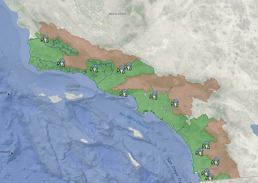
This portion of the story map shows the steelhead's current and historical ranges, as well as the locations of major dams.
July 11, 2016
Long Beach, California—July 11, 2016—The nonprofit Aquarium of the Pacific was recently honored with an award at the 2016 Esri International User Conference in San Diego, California, for its steelhead story map. The award Esri presented to the Aquarium was in the category of best use in science, technology, and education in a story map and was part of the 2016 Esri Storytelling with Maps contest. “The Aquarium’s winning story map was created to connect its guests and the general public with its Southern California Steelhead exhibit and tell the story of steelhead, including their transition from rainbow trout to steelhead salmon. We also wanted to help make people aware of the challenges faced by this now vanishing species,” said Dr. Jennifer Lentz, Aquarium of the Pacific education coordinator.
The Aquarium of the Pacific uses Esri ArcGIS technology, such as story maps and other interactive geospatial technologies (including Esri’s Urban Observatory app and NOAA’s Science on a Sphere®), to connect its diverse audience of 1.6 million annual on-site visitors to current marine and environmental science issues. These programs help guests construct an understanding of human relationships to environments and a changing global system. Ultimately, the Aquarium uses GIS as a tool to help fulfill the institution’s mission to instill a sense of wonder, respect, and stewardship for the Pacific Ocean, its inhabitants and ecosystems.
“The awards identify the organizations and people who are using the power of geography to make our world a better place,” says Esri President Jack Dangermond. “At Esri, we are always deeply inspired by the passion and innovation of our users. They deserve recognition for their invaluable contributions to their communities and the continued evolution of geographic science.” In addition, the second edition of Ocean Solutions, Earth Solutions was released at the conference. The book includes a chapter submitted by the Aquarium of the Pacific (Chapter 12 “More Than Maps: Connecting Aquarium Guests to Global Stories” by Jennifer Lentz, Emily Yam, Alie LeBeau, and David Bader).
About Esri: Since 1969, Esri has been giving customers around the world the power to think and plan geographically. The market leader in GIS, Esri software is used in more than 350,000 organizations worldwide including each of the 200 largest cities in the United States, most national governments, more than two-thirds of Fortune 500 companies, and more than 7,000 colleges and universities. Esri applications, running on more than one million desktops and thousands of Web and enterprise servers, provide the backbone for the world’s mapping and spatial analysis. Esri is the only vendor that provides complete technical solutions for desktop, mobile, server, and Internet platforms. Visit us at www.esri.com.
Discount tickets available at Ralphs for a limited time